How Junior Mining Projects Qualify for Investment and Development
Contents
A Guide to Our Due Diligence Process and Onboarding Requirements
If you are a junior mining company seeking investment, a joint venture partner, or a route to market through the Minestarters platform, this guide is for you. We have written it because we receive a significant volume of project submissions every quarter, and the majority of them, even promising ones, fail at the first hurdle not because the geology is bad, but because the documentation is incomplete, the data cannot be independently verified, or the project narrative has outrun the actual evidence.
This blog sets out clearly what we expect when you submit a project for consideration. It covers the documents you need to prepare, the scoring framework we use, the categories we grade, and the most common reasons applications stall or are rejected. Read it carefully before you approach us.
Who We Are and What We Are Looking For
Minestarters is a tokenised exploration finance platform that pools qualified and institutional investor capital into exploration-stage mining projects across Africa and beyond. Our typical project receives between USD 1 million and USD 2 million in exploration funding as part of a structured vault of five projects. Investors receive vault tokens backed by real project equity, and our platform takes a modest incubation fee plus a success fee on exit proceeds, meaning our incentives are directly aligned with making projects work.
We are not a grant body and we are not a charity. We are looking for projects with genuine economic upside, technically credible geology, and a management team that can execute. We have a rigorous scoring framework, and every project we consider is evaluated against the same criteria, regardless of commodity, jurisdiction, or the seniority of the person making the introduction.
The projects we want to back are those that score 70 or above on our 100-point evaluation framework, projects where the data tells a coherent story, the scale potential is real, and the team can be trusted to deploy capital responsibly. If your project is not yet at that level, that is not necessarily a rejection: it may mean there is a structured path to get there, and we can help you think through what that looks like.
The Documents You Need to Submit
The most common reason an application stalls is missing or unverifiable documentation. Our analysts cannot score what they cannot audit. Before submitting, you should have the following materials prepared and ready to share:
Core Technical Package
- Geological maps and cross-sections, clearly labelled with coordinate systems and scale
- Drill hole database or collar / assay tables, with associated QAQC reports (blanks, standards, duplicates)
- Geochemical dataset: soil, rock chip, channel or trench results, with sample IDs, coordinates, detection limits and laboratory certificates
- Geophysical data and interpretation: raw grids, processed products and the model used to rank targets (IP, magnetics, EM or gravity as appropriate)
- Any resource estimate, with the underlying block model and competent person sign-off , if the resource is non-compliant or historic, say so explicitly
- A clear geological narrative explaining the deposit model, host rocks, structural controls, and alteration signature
Tenure and Legal Documentation
- Current licence or permit documentation confirming title status, expiry dates and renewal path
- Evidence of payments, renewals or outstanding conditions attached to the licence
- Any known third-party claims, community agreements or encumbrances on title
Corporate and Financial Information
- Company registration and corporate structure documents
- Existing cap table and shareholder structure, including any existing convertible notes or prior investor agreements
- A summary budget for the proposed exploration programme, with unit costs and justification
- G&A cost breakdown, we flag any project where G&A exceeds 15-20% of exploration spend as a potential red flag
- If a resource or scoping study exists: a financial model or preliminary economic assessment with clear assumptions on commodity price, costs and recovery
Management and Team
- CVs or profiles of the technical team, including the geologist responsible for the exploration programme
- Track record of the key personnel, what projects have they taken from discovery to resource, resource to mine, or exit?
- Identification of any advisors, operators or JV partners already in the picture
You do not need to have all of these documents in a polished data room on day one, but you do need to be able to demonstrate that the underlying data exists and can be provided. Projects that rely entirely on narrative, anecdotal grades, or non-QAQC'd historical data will score poorly at the data quality gate and are unlikely to proceed.
How We Score Projects: The Six Categories
Every project we review is scored across six categories, giving a maximum of 100 points. Below is the full scoring framework, including what a good score looks like in each category.
Data Quality (Max 20)
.jpg)
Geology (Max 20)
.jpg)
Geochemistry (Max 20)
.jpg)
Geophysics (Max 10)
.jpg)
Scale Potential (Max 15)
.jpg)
Access & Team (Max 15)
.jpg)
The scores in each category are not just checklist items. They reflect the quality, consistency and credibility of the evidence you provide. A project with excellent geology but no QAQC'd assays will score well on geology and poorly on data quality. A project with a beautiful IP anomaly but no surface geochemistry to support it will score poorly on geochemistry, regardless of how exciting the geophysical picture looks.
Our Routing Framework: Where Your Project Ends Up
Once scored, every project is routed into one of four categories. This determines how we engage with it, and what, if anything, we are prepared to fund.
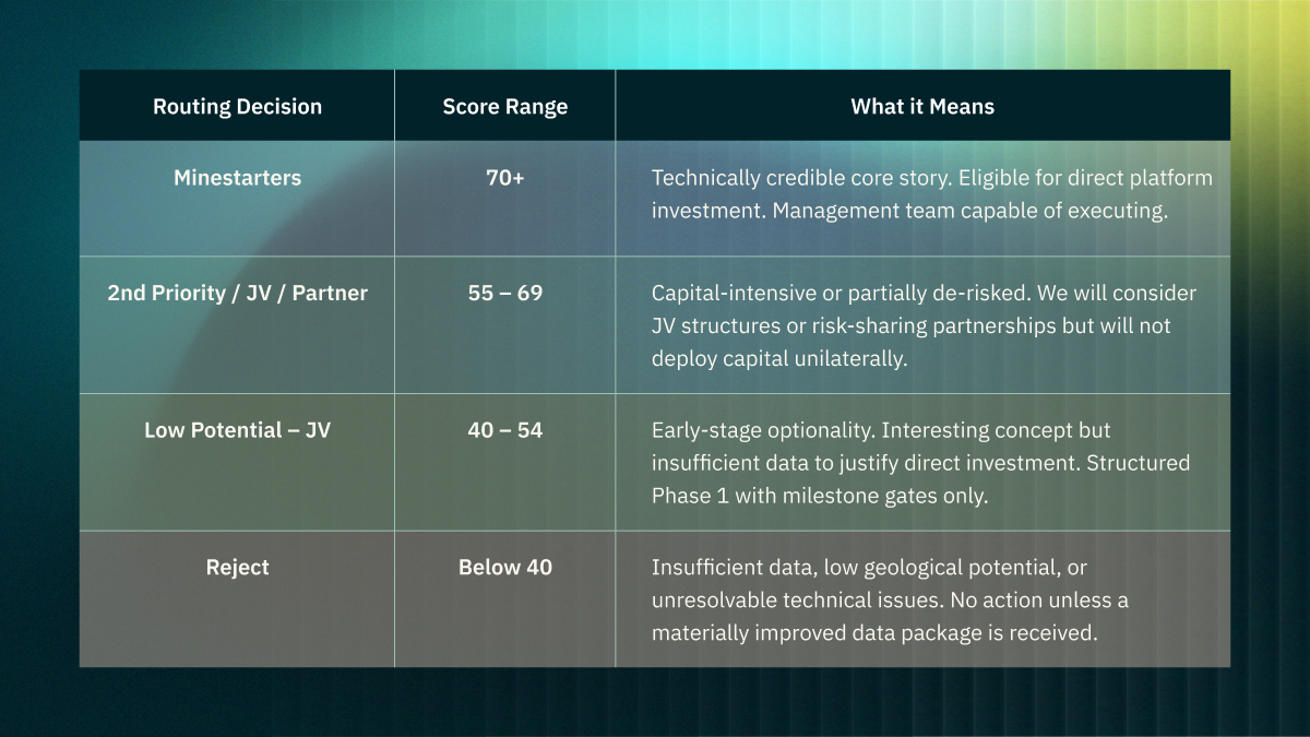
It is worth noting that a project scoring in the 55–69 range is not a dead end. Several projects in our current portfolio entered that bracket and have since moved into the primary investment category following targeted validation work. The routing framework is designed to be dynamic: if you can resolve the data gaps, the score moves.
What Gets Projects Rejected or Stalled: Common Gaps
Based on our review of project submissions to date, the following are the most frequent issues that result in a project being rejected, routed to the bottom tier, or placed on hold:
No QAQC
The single most common problem. Assay results without blanks, certified reference materials, and field duplicates cannot be trusted. If your laboratory reports do not include a QAQC summary, or if your project manager cannot tell you what standards were used, your data quality score will be very low regardless of what the numbers say.
Analytical Mismatches
We have reviewed projects where XRF and AAS results for the same samples differ materially, with no explanation offered. Grade claims that cannot be reconciled across analytical methods are not investment-grade. We require re-sampling and re-analysis in these cases before any capital is committed.
Non-compliant or Unverified Resources
A resource estimate that does not follow JORC 2012 or NI 43-101 is not a resource in any meaningful sense for our purposes. If you are quoting a historical estimate, you must say so clearly, disclose its basis, and explain why it has not been converted to a compliant resource. We see many applications that present conceptual resource numbers as though they were Indicated or Measured. This is an immediate red flag.
Geophysics Without Ground Truth
Magnetic or IP anomalies are not ore. Geophysics is a targeting tool. We regularly receive applications where a geophysical anomaly is presented as the primary evidence for mineralisation, with no soil, rock chip, trench or drill data to confirm it. We will not fund drilling on geophysics alone. You need surface geochemistry and, where possible, trenching before a drill decision can be justified.
Geology Driven by Narrative Rather Than Data
We appreciate enthusiasm. We do not fund enthusiasm. Applications that rely heavily on analogies to world-class deposits, conceptual geological settings, or historical workings that have never been systematically followed up will score poorly on geology and geochemistry. The model must be supported by data collected on the ground, by qualified people, using methods that can be replicated.
Incomplete or Unclear Tenure
If we cannot confirm that the licence is current, that renewal obligations have been met, and that there are no material encumbrances on title, we will not proceed. Title uncertainty is a hard stop. It does not matter how good the geology is if the project cannot be legally operated.
High G&A Relative to Exploration Spend
We flag any project where general and administrative costs represent more than 15-20% of the total exploration budget. This is a governance concern as much as a financial one. If overhead is consuming a large proportion of every dollar raised, investors are not getting value.
What Promising Metrics Look Like
To provide a practical reference for how exploration projects move into the upper tier of evaluation, the following metrics illustrate the types of technical signals that indicate a project may have genuine discovery potential. These metrics are not rigid thresholds but guidelines indicating geological coherence, scale potential, and reproducibility of exploration signals:
Geochemistry
Geochemistry is primarily used as a vectoring and targeting tool, not as proof of mineralisation. Strong projects demonstrate coherent, repeatable anomalies that align with geological controls and can be followed up systematically.
Coherent Anomaly Footprint
A soil or regolith anomaly extending at least 1.5–3 km in strike length along a structurally or lithologically meaningful corridor.
Indicative peak values may include:
- Gold: >100–300 ppb Au
- Copper: >300–500 ppm Cu
However, more important than peak values is a consistent anomaly population, where a large proportion of samples fall above background levels.
Signal-to-Background Contrast
A statistically meaningful contrast between background and anomalous populations, typically 4–5* background, supported by clear population separation in histograms or probability plots.
Multi-Element Pathfinders
Anomalies supported by geochemically compatible pathfinder elements, strengthening the mineralisation model. Examples include:
- Au systems: As, Sb, Bi, W, Te
- Cu systems: Mo, Ag, Co
- Porphyry systems: Cu-Mo-Au ± Bi-Te
- VMS systems: Cu-Zn-Pb ± Ba
A multi-element anomaly generally carries more exploration weight than a single-element anomaly.
Spatial Coherence
The anomaly should:
- Follow interpreted structures, stratigraphy, or intrusive contacts
- Align with mapped alteration zones
- Show clustered anomalous samples, rather than isolated spikes
Isolated “bullseye” anomalies without geological support are generally lower confidence targets.
Vectoring Indicators
Geochemical zoning patterns that suggest vectoring toward a mineralised centre, such as:
- Increasing metal tenor toward the core
- Systematic pathfinder element zonation
- Alteration-related geochemical halos
Surface Validation
Where possible, soil anomalies should be supported by:
- Rock chip results exceeding 1–2 g/t Au or 0.3–0.5% Cu
- Channel or trench samples demonstrating continuous mineralisation across structural features
Geophysics
Geophysical data should support geological interpretation, rather than act as a standalone exploration argument.
Promising indicators include:
IP or EM Responses
Chargeability or conductivity anomalies spatially coincident with geochemical anomalies and consistent with expected sulphide mineralisation.
Standalone geophysical anomalies without geochemical or geological support generally carry lower confidence.
Magnetic Architecture
Magnetic data outlining:
- Structural corridors
- Lithological contacts
- Intrusive bodies associated with mineralisation
Magnetic anomalies should assist in mapping controls on mineralisation, not simply highlight contrasts.
Integrated Interpretation
Strong exploration targets usually show overlap between multiple datasets, such as:
- Soil anomaly + IP chargeability
- Structural corridor + magnetic feature
- Surface mineralisation aligned with geophysical responses
Geology and Drilling
The geological model should be internally consistent and regionally appropriate.
Deposit Model Fit
The exploration model should align with known regional mineral systems, such as:
- Orogenic gold systems in greenstone belts
- Stratiform Cu-Co deposits in the Central African Copperbelt
- LCT pegmatites within recognised lithium provinces
- Porphyry Cu systems associated with calc-alkaline intrusions
Exploration concepts lacking a clear geological analogue generally carry higher risk.
Early Drilling Confirmation
Where drilling has commenced, promising signals include:
- Mineralisation intersected in multiple holes
- Consistent grade, thickness, and structural orientation
- Strong correlation between drilling and prior surface data
Data Quality
Reliable datasets should include:
- Detailed lithological and structural logging
- QA/QC procedures with blanks, standards and duplicates
- Transparent reporting of drilling methods and sampling protocols
Scale
Even strong geological signals must demonstrate potential economic scale.
Indicators of scale potential include:
Target Footprint
An exploration footprint capable of supporting a deposit in the order of:
- ≥500 koz Au equivalent, or
- ≥10–20 Mt base metal resources or equivalent, depending on grade and mining style
District Potential
Evidence that mineralisation occurs within a larger mineralised system, such as:
- Multiple targets within the licence area
- Repeated structural corridors
- Extension of favourable geology beyond current drilling
Stage Consistency
Project descriptions should match the level of available data.
- Early-stage projects should emphasise targets and geological potential
- More advanced projects should provide drilling results, geometry and resource estimates
Overstating project maturity without supporting data is generally viewed negatively by investors.
The Onboarding Process: What Happens Next
Our onboarding begins with a structured questionnaire that captures the key parameters of your project: commodity, jurisdiction, development stage, resource status, JORC compliance, team composition, tenure status, capital requirements, and existing investor arrangements. This is our intake gate.
From there, our analyst team completes a technical review against the six-category scoring framework. Projects are scored and routed, with a written summary of the key technical issues, a recommendation, and a defined set of next actions. If the score supports progression, we will request access to your full data room.
We aim to complete an initial score and routing decision within 10 business days of receiving a complete technical package. Incomplete submissions will be returned with a list of the missing materials required before review can begin. We do not hold submissions open indefinitely: if we have not received the required data within 30 days of flagging a gap, the application is closed.
We are not in the business of providing free technical advisory through the submission process. If you have a project that is clearly pre-submission in terms of data maturity, we would encourage you to work with a qualified geologist to prepare the package before approaching us.
A Final Word
We built Minestarters because we believe there is a generation of genuinely exciting junior exploration projects in Africa and beyond that cannot access the capital they need through conventional channels. The projects we back are not necessarily the most advanced or the most well-known, but they are technically credible, honestly presented, and capable of generating real returns for our investor community.
If your project meets the standards described in this guide, we want to hear from you. If it does not yet meet those standards, we hope this guide gives you a clear roadmap for what to work on before you do. The bar is high because our investors deserve it to be high, and because the projects that clear it are genuinely worth backing.
Submit your project through our onboarding portal. We look forward to reviewing it.